Exploring GPR Surveys in Surrey, UK, and the Role of Topographical Land Surveys in London and Surrey
In the modern era of urban development and infrastructure planning, accurate surveying techniques are essential for ensuring the success and safety of construction projects. Two key methods used in this regard are Ground Penetrating Radar (GPR) surveys and Topographical Land Surveys. In this article, we will delve into the significance of GPR surveys Surrey in UK, and the role of topographical land surveys in both London and Surrey.
Understanding GPR Surveys in Surrey, UK
What are GPR Surveys?
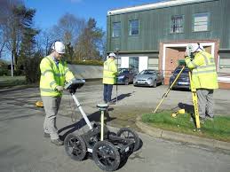
GPR surveys utilize ground-penetrating radar technology to create images of subsurface structures, utilities, and geological features. This non-invasive technique emits high-frequency electromagnetic waves into the ground and detects reflections from subsurface objects, providing valuable insights without the need for excavation.
Applications of GPR Surveys in Surrey
In Surrey, GPR surveys find numerous applications in various industries and sectors. These include:
Utility Mapping: GPR surveys are instrumental in mapping underground utilities such as water pipes, sewer lines, and electrical cables. By accurately identifying the location and depth of these utilities, construction projects can proceed without the risk of accidental damage.
Geological Investigations: Surrey’s diverse geological landscape makes it an ideal location for geological investigations using GPR technology. Surveyors can map subsurface features such as bedrock, soil layers, and geological faults, providing valuable data for geological studies and environmental assessments.
Archaeological Studies: Surrey boasts a rich cultural heritage, with archaeological sites dating back centuries. GPR surveys are used to identify buried artifacts, ancient structures, and archaeological remains, helping historians and archaeologists uncover the region’s past.
Benefits of GPR Surveys in Surrey
The use of GPR surveys in Surrey offers several key benefits:
Accuracy: GPR technology provides high-resolution images of the subsurface, allowing surveyors to accurately map underground features with precision.
Efficiency: GPR surveys can be conducted rapidly, minimizing downtime and disruption to ongoing construction projects.
Safety: By identifying potential hazards such as buried utilities or unstable ground conditions, GPR surveys help mitigate risks and ensure the safety of workers and the public.
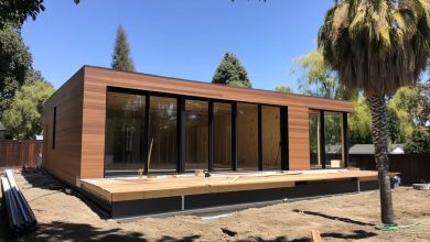
Exploring Topographical Land Surveys in London and Surrey
Role of Topographical Land Surveys
Topographical land surveys uk play a vital role in mapping the surface features and terrain of a given area. In both London and Surrey, these surveys provide essential data for urban planning, construction projects, and environmental management.
Applications of Topographical Surveys
Topographical surveys in London and Surrey are utilized in various contexts, including:
Urban Planning: Topographical surveys are essential for urban planners in assessing land use, infrastructure needs, and development opportunities. By accurately mapping the existing terrain and features, planners can make informed decisions about future development projects.
Engineering Design: Engineers rely on topographical surveys to design infrastructure projects such as roads, bridges, and drainage systems. Detailed topographic maps provide critical information on elevation, slopes, and drainage patterns, ensuring the efficiency and safety of engineering designs.
Land Development: In both London and Surrey, land developers use topographical surveys to assess the suitability of sites for residential, commercial, and industrial development. Survey data helps developers identify potential constraints and opportunities, guiding site design and layout decisions.
Advantages of Topographical Surveys
Topographical surveys offer several advantages:
Comprehensive Data: Topographical surveys provide comprehensive data on surface features, elevations, and contours, enabling detailed analysis and planning.
Accurate Measurements: Professional surveyors use advanced equipment and techniques to ensure accurate measurements and data collection, minimizing errors and discrepancies.
Regulatory Compliance: Topographical surveys comply with regulatory requirements and industry standards, providing reliable data for planning and permitting processes.
Comparative Analysis: GPR Surveys vs. Topographical Surveys
Differences in Methodology
While both GPR surveys and topographical surveys provide valuable information for construction and development projects, they differ in their methodology and applications.
GPR Surveys: Focus on imaging the subsurface and identifying buried objects, utilities, and geological features.
Topographical Surveys: Concentrate on mapping surface features, terrain, and elevation changes to support engineering and planning activities.
When to Choose Each Type of Survey
GPR Surveys: Ideal for projects requiring subsurface investigation, such as utility mapping, geological studies, and archaeological research.
Topographical Surveys: Suitable for projects involving surface mapping, site planning, engineering design, and land development.
Conclusion
In conclusion, GPR surveys play a crucial role in Surrey’s urban development and infrastructure planning, providing valuable insights into the subsurface landscape. Similarly, topographical land surveys are essential for mapping the surface features and terrain of both London and Surrey, supporting urban planning, construction projects, and environmental management efforts. By understanding the capabilities and applications of GPR and topographical surveys, stakeholders can make informed decisions and ensure the success of their projects.